Posts

Day 9: One last stop

Image
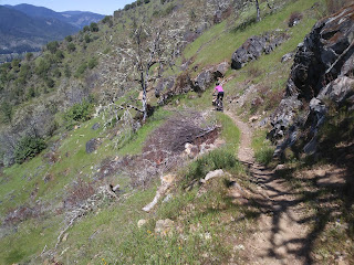
We awoke at 6:15 without an alarm, and showered in anticipation of a wonderful breakfast! Laura made some scrumptious banana muffins, and Charlie made a potato hash with fresh tomatoes. It was so good! We loaded up the car one last time, and as we started off, I said, let's just use your phone for navigation since you already have our planned ride in your Google Maps. Had I used mine like we had for the entire rest of the trip, I would have realized I left it on the nightstand. Shoot! Laura is mailing it to me tomorrow. That's why I have no photos for today or yesterday. Anyway, the folks we talked to on the ride yesterday recommended a ride that would be somewhat on our way home from Charlie's at Alsea Falls, so we headed for it. We arrived shortly before 11:00 (took us 2 3/4 hours) and got ready to ride. I studied the map at the reader board and worked out a ride, but just before we headed up, a local told us how to do it. We rode a paved road all the way to the top,

Day 8: It's all about the bike ride

Image
We learned some important lessons on this trip, the biggest one being to break up the long drives with mountain biking, trail running, or skiing. I'll save the others for later. Today was no exception to our new discovery; John suggested a couple of bike rides we could do on our way to North Bend, OR, and I did some research of my own. I found a location called Mountain of the Rogue, a newly-built mountain bike-specific trail system that is right next to I-5. What could be more perfect? We didn't want to go too far out of our way since we would be heading for North Bend (Coos Bay) after the ride to visit my brother, and it's on 101. Finding the trailhead was easy (it showed up in Google Maps). We got ready for the ride and encountered a few other riders who advised us on what trails to take as intermediate riders. The trail was perfect! It gradually switchbacked up the mountainside. It was kind of ugly--some burnt trees and then deciduous trees that hadn't opened ye

Day 7: The long drive home begins

Image
Aren't you supposed to sleep in on vacation? We got up at 5:00 again and were on the road by 6:00. We had planned to do a bike ride in Tehachapi, CA, but as I drove through, there was a black cloud hanging low over the entire area, and the temperature was 39 degrees. I woke John from his nap and he concurred that we should skip it. Our goal was Redding, CA, and by 2:00, it was clear we would make it, so I used my phone to find an Airbnb in Redding. I was able to get us a cute one-room cottage on a ridge above town. After 11 hours in the car, we heated up the spaghetti I had made the night before and updated the blog. Tomorrow, we hope to ride or run in Roseburg, OR, and then we head to my brother's in North Bend, OR, for a visit. Ellen and John

Day 6: The highlight of the trip

Image
We were in the car and headed for the park at 5:30 AM today, and I think we were both half asleep! We made the long drive to the Cholla Cactus Gardens for a sunrise shoot--we just barely made it in time to capture the golden light on the cactus blooms. Cholla cactus It was even better than shooting it at sunset the first night, and I was delighted by a hummingbird moth. It seems to be a morning creature that hovers above the flowers, beating its wings and touching the blooms with its long, hooked beak (?). It was about an inch long. I had to wait quite a while to photograph one, as they flit about quite a bit just like a hummingbird. Next we headed to the eastern end of the park near Cottonwood Campground for the Lost Palms Oasis Trail. This 7.4-mile hike was to be our run for the day. It was truly the highlight of the entire trip. The trail was fairly easy-going with lots of ups and downs as we ran in and out of washes. The wildflowers were more prolific, varied, and ab

Day 5: Seeing the park

Image
Our day started at 5:30 to get to our morning shoot at Key View. It didn't turn out to be a good place so we tried to salvage the morning by shooting the Joshua trees in Juniper Flats. The golden light was pretty much gone in the jungle of Joshua Trees, but we tried. At least I got some much needed practice. Then we were off for a challenging 6.6 mile trail run, Lost Horse Mine Loop. There was a lot of steep climbing for the first two miles to the mine and then a tricky descent only to climb again. About half way through the trail leveled out and began a gradual descent back to the parking lot.  It was a beautiful run with amazing views. Garmin run data:  https://connect.garmin.com/modern/activity/1677916924 John starts up the Lost Horse Mine Loop. Tough climb and we were at over 4000 feet of elevation. I didn't think I would notice (Missoula is 4000+ and I've run there) but we both had trouble catching our breath, The remnants of the mine We paused

Day 4: A most intriguing landscape

Image
We slept in until 7:00 and had pancakes and some slices of ham-ish loaf for breakfast. We were reluctant to leave our place in Desert Hot Springs. There were so many nice seating areas in the yard. But we headed out around 9:00 for Joshua Tree National Park. We entered using the West Entrance and had to wait in line about 15 minutes. Once in, John chose Hidden Valley Loop for our trail run. It was a one-mile loop that we did multiple times. Lots of families and little kids. Scenic but crowded. From there, we grabbed our peanut or in my case almond butter and jam sandwiches and headed for a rock in the sun to eat. Then we drove further into the park. John took me to Jumbo Rocks Campground where he stayed last time he was here. We parked the car and walked out into the rocks. You don’t have to follow a trail, which seemed weird, but it’s allowed. It was great fun. The rocks are granite and incredibly grippy. I started noticing the many different wildflowers, and that quickly bec

Day 3: Desert sunshine!

Image
Our day began early again at 5:40. We threw on some clothes, grabbed some coffee and OJ and headed for Mt. Whitney Portal and nearby Alabama Hills for a shoot. It was a whopping 33 degrees when we got out of the car. I had on a long sleeve running shirt, a wool sweater, a winter biking jacket, and a light weight down jacket over that! The main thing that got cold was my hands, having to take them out of my gloves to change the settings on the camera. To say I am rusty is like saying it only rains for a few days in Seattle. I am also using a new camera, a Cannon 80D. I ended up shooting in AV mode, and my best shots were using the auto mode as we headed back to the car. But I am getting ahead of myself. The Mt. Whitney Portal didn't offer very good comps, though John thinks that's where I got my best photo. We spent the sunrise here and then headed back down towards Alabama Hills. We had a little trouble finding the right road (tiny sign that says Movie Rd.) and took the wro